Langkah seterusnya diteruskan ke destinasi hari ke 4 yang masih tak kunjung sampai.
Memang dalam itinerary kami dah agak yang kami akan sampai ke destinasi akhir hari ni pada malam hari. So dalam perjalanan ni. memang kami akan singgah menyinggah mana mana kawasan yang di rasakan OK plus beberapa tempat yang telah di plan oleh IH awal awalnya.
Dari Omarama kami menyusuri highway 83. Dan tak jauh dari pekan Omarama tadi, kami sekali lagi bertemu dengan sebuah tasik yang tak kurang cantiknya.
Lake Benmore !

Terpukau sekejap dengan daun daun yang bertukar warna di sini
Lake Benmore ni agak besar jugak dan laluan yang kami tempuhi memang melalui tepi kawasan tasik yang boleh tahan besarnya ni.
Lalulintas agak sepi tapi dekat area tasik tu nampak macam ada orang beriadah, piknik dan berlari.
So, ayuh kita singgah ! Buat buat sibuk.

Lake Benmore
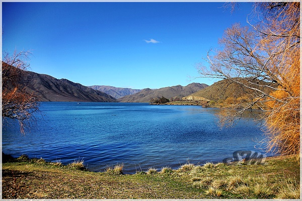
Tasik yang tenang tapi di larang memancing
Lake Benmore is a lake located in the South Island of New Zealand. It was artificially created in the 1960s by construction of Benmore Dam. The lake covers an area of approximately 75 km². Parts of it lie in the Mackenzie, Waimate, and Waitaki districts within the southern portion of the Canterbury Region.
The major rivers with which it is fed are the Ohau, Pukaki, Tekapo and Ahuriri Rivers. Immediately downstream is Lake Aviemore. The lake has New Zealand's largest earth dam as part of the Waitaki hydroelectricity power scheme.
After the lake was created the incidence of seismic shocks increased by a factor of three to six times
Berhenti di hentian pertama, then jalan tak sampai beberapa KM, singgah lagi, kali ni di Lake Aviemore yang sebenarnya bersambung dengan Lake Benmore tadi.
Kali ni BW dengan cubaan nak terkencing. Kuasa bomoh dia meramalkan, mesti ada toilet kat sini. Jadi kami singgah lagi.

Lake Aviemore belah depan sikit

Bawah pokok tu ada orang melepak lepak

Lake Aviemore yang mengalir ke arah pintu empangan
Lake Aviemore or Mahi Tikumu is a man-made lake in New Zealand's South Island, part of the Waitaki hydroelectric scheme. Immediately upstream is Lake Benmore and downstream Lake Waitaki. Aviemore lies on both sides of the border between the Waimate and Waitaki districts.
It is part of the traditional boundary of the Canterbury and Otago regions, although, officially, the border has been moved southward to include the lake, as well as the entire northwestern portion of the Waitaki District in the Canterbury Region. The Otematata settlement situated on State Highway 83 is just west of the lake, and was built in 1958 as a base for the construction of the Aviemore and Benmore Dams. Closer to the lake the old village Wharekuri which encompasses Aviemore was populous in the 1860s.
The Aviemore Dam, completed in 1968, is the newest of the three dams on the Waitaki river. It is made out of both earth and concrete.
By continuing the sinuous course of the river after the lake, one encounters Parsons Rock, named after Reverend J.C. Andrew (The Parson) who usually gave Christmas day sermon there. A story goes to say that stolen gold taken from the Wharekuri Hotel was hidden near Parsons Rock.The suspects were to be apprehended but no money was ever found by the authorities in the hiding place.
In both Lake Aviemore and Benmore, one can fish salmon and trout year round except in September. Two main events are held on Lake Aviemore, there is the Labour weekend Aviemore Classic Trailer yacht race and the Windsurfing Championships in January.
Nampak tak aku malas so main tempek je info dari wiki.
Eh, BW tadi kata dia nak kencing kan? Tekaan dia memang betul ! Ada toilet kat sini. Tapi.................

Tengah tengah padang !... Boleh nampak sapa yang nak pegi tandas ni dari jauh. Hahaha.
BW tu drama je lebih. Memula nak kencing lah apa lah. Bila tengok tandas macam tu terus tak jadi ! Plus air tak der dan keadaannya tak berapa bersih mana !
Skip. Tahan lah kau BW daripada kencing. Rosak buah pinggang aku tak tau !.
Then kami sambung jalan lagi.

Lalu kawasan cenggini

Lawa jugak sebenarnya scenery

Jalan raya di laluan tepi tasik tasik ni

Damai je rasa. Driving pun tak payah laju laju. Nikmati suasana dan keindahan di NZ ni.

Sampai kawasan hujung. Waitaki Dam. Ada lookout kat sini, kami gi usha jugak tapi tak de la lawa mana pun. Tempat tempat tadi lawa lagi.
Tapi kalau asyik berhenti henti je, bila nak sampai ni?
"Dah ! Last berhenti.. Lepas ni tak de dah !!"
Macam tu aku marah ! Padahal bukan aku yang drive pun.
Tak lama lepas tu, tetiba nampak view lawa lagi.
"Chop !!! 5 minit. 5 minit jerrrr... !"
Berhenti lagi.

Kawasan ni part of the same tasik jugak lah, cuma area ni nampak menarik juga

So berhenti lagi ambik ambik gambar

Ada kapal
Aku kalau berhenti memang ambik gambar kejap je sebab main snap. Tapi dia orang tu sebab nak bergaya dan berposing, selalu ambik masa agak lama.
"5 minit !!! Cepat !!!!"
Begitu aku selalu menjaga masa..............

Snap satu dua lagi
Lepas tu kami melintasi pekan Kurow.

Selamat datang !
Kurow is a small town in the Waitaki District, New Zealand. It is located on the south bank of the Waitaki River, 60 kilometres (37 mi) northwest of Oamaru. At the 2013 Census, the town had a population of 312 people
The name is an Anglicised form of the name of the nearby mountain Te Kohurau.
In the 1920s the town was the base for the building of the nearby Waitaki Dam and forming Lake Waitaki in the first of a series of hydroelectric projects on the Waitaki River.
The first social security scheme for New Zealand workers was designed in the town, arising from Presbyterian Minister of Kurow Arnold Nordmeyer's experience of working with families of workers on the Waitaki hydro-electric project
Kecik je pekan dia. Tapi setiap kali masuk pekan di NZ ni, hadlaju akan berkurang secara automatik. Kalau biasa 80 KM/J, masuk bandar jadi 50 KM/J. So kena la bawak dengan bertomakninah.
Apa yang aku perasan dan suka di setiap pekan yang di lalui di NZ ni, mesti ada satu bangunan yang membezakan pekan ni dengan pekan pekan yang lain. Boleh di perhatikan, kalau masuk je area pekan, mesti kalau tak bangunan, mesti ada petanda yang paling tidak pun menjadi landmark setiap pekan pekan ni.

Contohnya di Kurow ni ada bangunan kaler macam ni.

Dan jugak macam ni.

Tak singgah pun. Perjalanan di teruskan lagi

Berhenti kejap sebab nak ambik gambar lembu tepi jalan.

Buleh pulak tetiba lembu ni mengongkek di khalayak umum. Tak tahu malu sungguh !
Lebih kurang 20 minit pemanduan, kami akhirnya memasuki pekan yang bernama Duntroon !
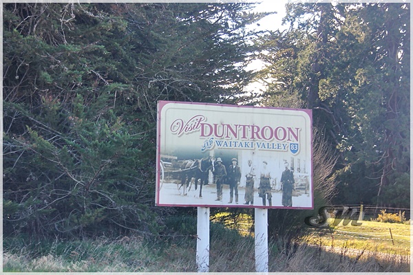
Welcome to Duntroon
Duntroon (from Scottish Gaelic: Dùn Treòin) is a small farming town in the Waitaki District of New Zealand's South Island. Although traditionally considered a North Otago town, it is located within the farthest southern reaches of Canterbury.
Just north of the town is the Waitaki River that forms the traditional border between the two regions, although the official border has now been moved south to put most of Waitaki District within Canterbury, including Duntroon. To the east of the village is the Maerewhenua River. Near the village are the Earthquakes, a limestone cliff formation.

Gereja di Duntroon

Dan yang menarik di pekan ni, banyak bangunan kaler pink !

Di Duntroon ni jugak ada Maori Cave Paintings. Tapi kami tak singgah pun.
5 kilometres (3 mi) south of Duntroon, in the Maerewhenua Valley, a group of large rock formations called "Elephant Rocks" has been used as a filming location for the first Chronicles of Narnia movie in 2005.[2] The rock formations are located in a private field and can be seen from the road.
Yes. Itu lah destinasi kami seterusnya. Elephant Rocks !

Sebab hari pun dah hampir petang, kami bergegas ke lokasi nak singgah seterusnya iaitu Elephant Rocks yang terletak di Duntroon ni

Tapi laluan dia kena masuk dalam sikit

Jalan dia agak confusing sebab tak de penanda arah

Yang akhirnya membawa kami ke Elephants Rocks ni

Ada pelawat lain masa tu.
So sebab tempat ni tepi jalan dan dalam kawasan ternakan kambing biri biri, maka park tepi jalan tu je lah dan jalan kaki ke kawasan dia.
The Elephant Rocks near Duntroon in North Otago, New Zealand, are a collection of large weathered limestone rocks. They are located on a private farm 5 kilometres (3 mi) south of Duntroon, in the Maerewhenua Valley. The wider area around Duntroon is known for its interesting geology and preserved fossils.
The Elephant Rocks are the weathered remnants of the Otekaike Limestone formation which lies above the Oligocene Kokoamu Greensand.
Dah sampai, apa lagi. Usha lah !
Tapi sebelum nak sampai ke Elephant Rocks tu kena bertarung dengan rasa berani. Kena pandai pandai mengelak taik kambing biri biri yang bersepah sepah ni.

Biri biri ni memang banyak. Dekat tapi nak tangkap tak boleh !

Pantang dekat je, laju je dia orang lari. Terpekik telolong pulak tu.. Macam lah aku nak cabul !

Dua ekor ni comel sungguh. Bersungguh aku kejar nak tangkap. Sampai sudah tak dapat. Sikit sikit mengadu kat mak bapak dia.

Sampai sudah aku kejar tak dapat dapat !
Malas layan kambing kambing ni.
Quit playing game with my hearts !
Even in my heart I see
You're not bein' true to me
Deep within my soul I feel
Nothing's like it used to be
Sometimes I wish I could turn back time
Impossible as it may seem
But I wish I could so bad baby
Quit playin' games with my heart
Quit playin' games with my heart (with my heart)
Before you tear us apart (my heart)
Quit playin' games with my heart
I should've known from the start
You know you've gotta stop (from my heart)
You're tearin' us apart (my heart, my heart)
Quit playin' games with my heart
I live my life the way
To keep you comin' back to me
Everything I do is for you
So what is it that you can't see
Sometimes I wish I could turn back time,
Impossible as it may seem
But I wish I could so bad, baby
You better quit playin' games with my heart
Quit playin' games
Baby, baby the love that we had was so strong
Don't leave me hangin' here forever
Oh baby, baby this is not alright, let's stop this tonight
Baby, oh
Quit playin' games
Na na na na na na
Na na na na na baby
Na na na na na
Sometimes I wish I could turn back time,
Impossible as it may seem
But I wish I could so bad, baby
Quit playin' games with my heart
Quit playin' games with my heart
Na na na na na na
Na na na na na baby
Na na na na na
Kau mampu tuju lagu kat kambing?????
Now, masa untuk usha rock formation Elephant Rocks di sini.

Banyak batu batu macam ni. Aku sendiri pun tak pasti apa benda yang buat nama dia Elephant Rocks sedangkan tak de rupa elephants pun.
The rock formations of the Elephant Rocks vary from 1–10 metres (3–33 ft) across and are naturally scattered around a grass paddock on a gentle hillside over an area of about 200 metres (660 ft) across. The rocks themselves are rounded and pockmarked from weathering, but do not specifically resemble elephant shapes. The pasture is part of a private farm, and sheep may be present. Access is permitted via a 5-minute walk across the farmland from opposite a parking bay on the Island Cliff-Duntroon Road.
The Elephant Rocks area has been used as a filming location for the first Chronicles of Narnia movie in 2005 when it was transformed into Aslan's camp

Ni macam rupa singa je

Ni ada sikit sikit macam gajah

Ni gajah terpenyek?

Kawasan Elephant Rocks

Formasi batu batu di kawasan ni
Tapi misi sampai sudah gagal.
Kami tak spent lama mana kat situ, lepas kecewa dengan biri biri yang sombong bongkak riak dan angkuh di situ, kami gi usha lembu lah.

Mereka sedang bersidang !

Padang ragut mereka

Kehijauan
Lepas abiskan masa lebih kurang di kawasan ni, kami bergerak lagi. Kali ni ke destinasi singgahan terakhir untuk hari ni.
Harapnya kami sempat sampai sebelum hari gelap.

Laluan saujana mata memandang
Lepas ni janji tak de stop stop dah di perjalanan.
Kena kejar masa. Jangan sampai malam menjelma......................
bersambung...........


Tasik yg ni nmpk mcm natural lake compared dgn yg sblm ni
ReplyDeletehaah. yang tu dia buat hydro electric.. yang ni tasik dia besar skit
Deleteaduhai..scenery kat NZ ni...kalau drive asyik nak berenti sebulan le baru abis roadtrip haha..
ReplyDeleteada tengok video Alex Chacon guna drone kat area elephant rock ni, memang aummm sangat
tu lah. ikut kan nak berhenti.. naik basikal la baru puas enjoy the view.
Deletecantiknyeeee...
ReplyDeletetu lah.... kalau kat malaysia agaknya dah penuh dgn sampah sarap
DeleteSaya seringkali terpukau dengan daun-daun yang bertukar warna.
ReplyDeleteberjiwa encik MKL nih
DeleteRoadtrip kar nz mesti kena ada sorang jaga masa..kalu tak sampai sudah tak sedar diri amik gambo sana sinj..hihi.
ReplyDeletebetul.... tapi geng travel kena sekepala. kang nak ambik gambar ada yang tarik muka tak sudah sudah.
Deleteapa yang penting.......... kerjasama dan tolerasi !